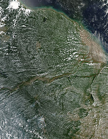
Thursday, June 25, 2015

Atlantic Forest

The Atlantic Forest (PortugueseMata Atlântica) is a terrestrial biome and region which extends along the Atlantic coast of Brazil from Rio Grande do Norte state in the north to Rio Grande do Sul state in the south, and inland as far asParaguay and the Misiones Province of Argentina.
The Atlantic Forest has ecoregions within the following biome categories: Tropical and subtropical moist broadleaf forestsTropical and subtropical dry broadleaf forestsTropical and subtropical grasslands, savannas, and shrublands, and Mangrove forests. The Atlantic Forest is characterized by a high species diversity and endemism.[1]
It was the first environment that the Portuguese colonizers encountered over 500 years ago, when it was thought to have had an area of 1,000,000 to 1,500,000 km2 (390,000 to 580,000 sq mi), and stretching an unknown distance inland.[2] Currently, the Atlantic Forest spans over 4,000 km2 (1,500 sq mi) along the coast of Brazil and in a small part of Paraguay and Argentina.[3][4] In Argentina, it is known as Selva Misionera.The Atlantic Forest region includes forests of several variations:
  • Restinga is a forest type that grows on stabilized coastal dunes. Restinga Forests are generally closed canopy short forests with tree density. Open Restinga is an open, savanna-like formation with scattered clumps of small trees and shrubs and an extensive layer of herbs, grasses, and sedges.[3]
  • Tropical moist forests are forests that receive more than 2000 mm of rain a year. This includes Lowland Tropical Moist Forests, Submontane Tropical Moist Forest, and Montane Tropical Moist Forest.[3]
  • Tabuleiro forests are found over very moist clay soils and Tabuleiro Savannas occur over faster-draining sand soils.[3] These are humid areas that rely on water vapor from the ocean.[4]
  • Further inland are the Atlantic dry forests or seasonal forests, which form a transition between the arid Caatinga to the northeast and the Cerrado savannas to the east. These forests are lower in stature; more open, with high abundance of deciduous trees and lower diversity when compared to tropical moist forests. These forests have between 700–1600 mm of precipitation annually with a distinct dry season. This includes Deciduous and Semideciduous Seasonal Forest each with their own lowland and montane regions.[3][4]
  • Montane moist forests are higher altitude wet forests across mountains and plateaus of southern Brazil.
  • Shrubby montane savannas occur at the highest elevations, also called Campo rupestre.
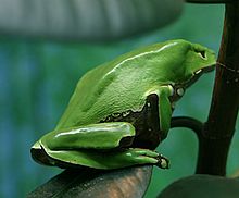
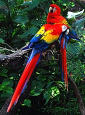
The Atlantic Forest is unusual in that it extends as a true tropical rainforest to latitudes as high as 24°S. This is because the trade winds produce precipitation throughout the southern winter. In fact, the northern Zona da Mata of northeastern Brazil receives much more rainfall between May and August than during the southern summer.During glacial periods in the Pleistocene, the Atlantic Forest is known to have shrunk to extremely small fragmented refugia in highly sheltered gullies, being separated by areas of dry forest or semi-deserts known as caatingas.[4] Some maps even suggest the forest actually survived in moist pockets well away from the coastline where its endemic rainforest species mixed with much cooler-climate species. Unlike refugia for equatorial rainforests, the refuges for the Atlantic Forest have never been the product of detailed identification.Despite so little forest remaining, the Atlantic Forest remains extraordinarily lush in biodiversity and endemic species, many of which are threatened with extinction. Approximately 40 percent of its vascular plants and up 60 percent of its vertebrates are endemic species, meaning they are found nowhere else in the world.[5] The official threatened species list of Brazil contains over 140 terrestrial mammal species found in Atlantic Forest. In Paraguay there are 35 species listed as threatened, and 22 species are listed as threatened in the interior portion of the Atlantic Forest of Argentina. Nearly 250 species of amphibians, birds, and mammals have become extinct due to the result of human activity in the past 400 years. Over 11,000 species of plants and animals are considered threatened today in the Atlantic Forest.[4]
Over 52% of the tree species and 92% of the amphibians are endemic to this area. The forest harbors around 20,000 species of plants, with almost 450 tree species being found in just one hectare in some occasions.[6]
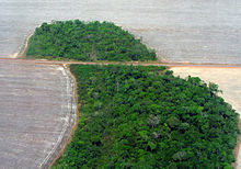
New species are continually being found in the Atlantic Forest. In fact, between 1990 and 2006 over a thousand new flowering plants were discovered. Furthermore, in 1990 researchers re-discovered a small population of the black-faced lion tamarin (Leontopithecus caissara, previously thought to have been extinct.[7] A new species of blonde capuchin (Cebus queirozi), named for its distinguishing bright blonde hair, was discovered in northeastern Brazil at the Pernambuco Endemism Center in 2006.[8] A species of endangered three-toed sloth, named the maned sloth (Bradypus torquatus) because of its long hair, is endemic to the Atlantic Forest.[9]The incorporation of modern human societies and their needs for forest resources has greatly reduced the size of the Atlantic Forest, which has resulted in species impoverishment.[10] Almost 88% of the original forest habitat has been lost and replaced by human-modified landscapes including pastures, croplands, and urban areas. This deforestation continues at an annual rate of .5% and up to 2.9% in urban areas.
Agriculture: A major portion of human land use in the Atlantic Rain Forest is for agriculture. Crops include sugar-cane, coffee, tea, tobacco and more recently soybean and biofuel crops.[5]
Pasture: Even more common than using land for agriculture is the conversion of forest to cattle pastures.[11] This is commonly done by method of slash and burn which increases a forest chance of human-induced burning.
Hunting: Species in a fragmented forest are more susceptible to decline in population size because they are in an confined area that is more accessible to hunters. Larger animals make up the highest percentage of biomass. These animals are also the most rewarding to hunters and are heavily hunted in accessible fragments. This results in a change in species interactions such as seed dispersal and competition for resources.
Logging: Logging removes 10 to 80% of the canopy cover of a forest making that habitat more susceptible to natural elements such as wind and sunlight. This causes an increase in forest heating and desiccation.[12] Large amounts of organic litter and debris builds up which results in an increase in forests vulnerability to fires. Additionally, logging roads create accessibility for humans; and therefore increases the amount of human land disturbances and decreases the amount of natural forest.[12]
Fire: Human activity such as logging causes an increase in debris along forest floors that makes the Atlantic Forest more susceptible to fires. This is a forest type that is not accustomed to regular fire activity, so human induced fires dramatically affect the forest understory because plants do not have fire adaptations. In result, the forest becomes even more vulnerable to secondary fires, which are far more destructive and kill many more species including large trees.[12]

Results of Human Activity[edit]

Habitat fragmentation leads to a cascade of alterations of the original forest landscape.[5] For example, the extent of human disturbances, including habitat destruction, in the Atlantic Forest has led to an extinction crisis.[13] The endemic species in this region are especially vulnerable to extinction due to fragmentation because of their small geographic ranges and low occurrence.[14] In a study of the Atlantic Forest fragments, community level biomass was reduced to 60% in plots less than 25 hectares.[15] Key ecological processes such as seed dispersal, gene flow, colonization and other processes are disturbed by fragmentation.[15] With many key vertebrate seed dispersers going extinct, it is predicted that many regional, fruit-bearing tree species in the Atlantic forest will become extinct due to failure of seedling recruitment and recolonisation.[11] With all these species already threatened, it is predicted that with the persistence of current deforestation rates the Atlantic forest will see continued extinction of species.[13]

Conservation and nongovernmental organizations[edit]

Due to the Atlantic Forest’s vast diversity of endemic plants and animals as well as the fragmentation affecting these species, many groups and organizations are working towards the restoration of this unique ecosystemNon-governmental organizations (NGO) are huge benefactors in Brazil, providing funding as well as professional help to the Atlantic Forest due to the Brazilian Environmental Movement.[16] One organization, called BirdLife International, is using their research to preserve bird biodiversity of the area by primarily working with people towards sustainability in the use of natural resources.[16]
Some organizations are receiving grants from the Critical Ecosystem Partnership Fund (CEPF) if they abide by their directions.[16] These include:
  • Species protection program
  • The Program for Supporting Private Natural Heritage Reserves
  • The Institutional Strengthening Program
Another strategy being implemented to maintain biodiversity within the Atlantic Forest is creating wildlife corridors. The World Bank is donating $44 million to create a corridor, which will be known as the Central Biodiversity Corridor, in the Atlantic Forest and one in the Amazon.[16] The Brazilian Development Bank has been financing, with non-reimbursable loans, 16 to 18 ecosystem restoration projects totaling 3,500 hectares and costing approximately $22 million under the so-called Iniciativa BNDES Mata Atlântica.[17] In order to preserve diversity, the state of Sao Paulo has created the Restinga de Bertioga State Park, a 9.3 thousand hectares park which is also serves as a wildlife corridor linking the coastal regions to the Serra do Mar mountain range.[18] Some organizations, such as the Nature Conservancy, are planning to restore parts of the forest that have been lost and to build corridors that are compatible with the lifestyles of the native people.[19] TheAmazon Institute is active in reforestation efforts in the northeastern state of Pernambuco, Brazil. During 2007, Joao Milanez and Joanne Stanulonis have planted 5,500 new trees in the mountains commencing with Gravata, adding to the precious little, ancient forest left.
The Pact for Atlantic Forest Restoration has assembled over 100 businesses, nongovernmental and governmental organizations around the goal of having 15 million hectares of the original ecosystem restored by 2050.

Amazon rainforest

The Amazon rainforest (PortugueseFloresta Amazônica or AmazôniaSpanishSelva AmazónicaAmazonía or usually AmazoniaFrenchForêt amazonienneDutchAmazoneregenwoud), also known in English as Amazonia or the Amazon Jungle, is a moist broadleaf forest that covers most of the Amazon Basin of South America. This basin encompasses 7,000,000 square kilometres (2,700,000 sq mi), of which 5,500,000 square kilometres (2,100,000 sq mi) are covered by the rainforest. This region includes territory belonging to nine nations. The majority of the forest is contained within Brazil, with 60% of the rainforest, followed by Peru with 13%, Colombia with 10%, and with minor amounts in Venezuela, Ecuador, Bolivia, Guyana, Suriname and French Guiana. States or departments in four nations contain "Amazonas" in their names. The Amazon represents over half of the planet's remaining rainforests, and comprises the largest and most biodiverse tract of tropical rainforest in the world, with an estimated 390 billion individual trees divided into 16,000 species.The name 'Amazon' is said to arise from a war Francisco de Orellana fought with a tribe of Tapuyas and other tribes from South America. The women of the tribe fought alongside the men, as was the custom among the tribe.[2] Orellana derived the name Amazonas from the mythical Amazons of Asia described by Herodotus and Diodorus in Greek legends.The rainforest likely formed during the Eocene era. It appeared following a global reduction of tropical temperatures when the Atlantic Ocean had widened sufficiently to provide a warm, moist climate to the Amazon basin. The rainforest has been in existence for at least 55 million years, and most of the region remained free of savanna-type biomes at least until thecurrent ice age, when the climate was drier and savanna more widespread.[3][4]
Following the Cretaceous–Paleogene extinction event, the extinction of the dinosaurs and the wetter climate may have allowed the tropical rainforest to spread out across the continent. From 66–34 Mya, the rainforest extended as far south as45°. Climate fluctuations during the last 34 million years have allowed savanna regions to expand into the tropics. During theOligocene, for example, the rainforest spanned a relatively narrow band. It expanded again during the Middle Miocene, then retracted to a mostly inland formation at the last glacial maximum.[5] However, the rainforest still managed to thrive during these glacial periods, allowing for the survival and evolution of a broad diversity of species.[6]
Aerial view of the Amazon rainforest.
During the mid-Eocene, it is believed that the drainage basin of the Amazon was split along the middle of the continent by the Purus Arch. Water on the eastern side flowed toward the Atlantic, while to the west water flowed toward the Pacificacross the Amazonas Basin. As the Andes Mountains rose, however, a large basin was created that enclosed a lake; now known as the Solimões Basin. Within the last 5–10 million years, this accumulating water broke through the Purus Arch, joining the easterly flow toward the Atlantic.[7][8]
There is evidence that there have been significant changes in Amazon rainforest vegetation over the last 21,000 years through the Last Glacial Maximum (LGM) and subsequent deglaciation. Analyses of sediment deposits from Amazon basin paleolakes and from the Amazon Fan indicate that rainfall in the basin during the LGM was lower than for the present, and this was almost certainly associated with reduced moist tropical vegetation cover in the basin.[9] There is debate, however, over how extensive this reduction was. Some scientists argue that the rainforest was reduced to small, isolated refugiaseparated by open forest and grassland;[10] other scientists argue that the rainforest remained largely intact but extended less far to the north, south, and east than is seen today.[11] This debate has proved difficult to resolve because the practical limitations of working in the rainforest mean that data sampling is biased away from the center of the Amazon basin, and both explanations are reasonably well supported by the available data.

Sahara Desert dust windblown to the Amazon

More than 56% of the dust fertilizing the Amazon rainforest comes from the Bodélé depression in Northern Chad in the Sahara desert. The dust containsphosphorus, important for plant growth. The yearly Sahara dust replaces the equivalent amount of phosphorus washed away yearly in Amazon soil from rains and floods.[12]
Up to 50 million tonnes of Sahara dust per year are blown across the Atlantic Ocean.[13][14]
NASA’s CALIPSO satellite has measured the amount of dust transported by wind from the Sahara to the Amazon: an average 182 million tons of dust are windblown out of the Sahara each year, at 15 degrees West longitude, across 1,600 miles over the Atlantic Ocean(some dust falls into the Atlantic), then at 35 degrees West Longitude at the eastern coast of South America, 27.7 million tons(15%) of dust fall over the Amazon basin, 132 million tons of dust remain in the air, 43 million tons of dust are windblown and falls on the Caribbean Sea, past 75 degrees West Longitude.[15]
CALIPSO uses a laser range finder to scan the Earth’s atmosphere for the vertical distribution of dust and other aerosols. CALIPSO regularly tracks the Sahara-Amazon dust plume.
CALIPSO has measured variations in the dust amounts transported— an 86 percent drop between the highest amount of dust transported in 2007 and the lowest in 2011.
A possibility for the variation is the Sahel, a strip of semi-arid land on the southern border of the Sahara. When rain amounts in the Sahel are is higher, the volume of dust is lower. The higher rainfall could make more vegetation grow in the Sahel, leaving less sand exposed to winds to blow away.[16]

Human activity

Based on archaeological evidence from an excavation at Caverna da Pedra Pintada, human inhabitants first settled in the Amazon region at least 11,200 years ago.[17] Subsequent development led to late-prehistoric settlements along the periphery of the forest by AD 1250, which induced alterations in the forest cover.[18]
Geoglyphs on deforested land in the Amazon rainforest, Acre.
For a long time, it was thought that the Amazon rainforest was only ever sparsely populated, as it was impossible to sustain a large population through agriculture given the poor soil. Archeologist Betty Meggers was a prominent proponent of this idea, as described in her book Amazonia: Man and Culture in a Counterfeit Paradise. She claimed that a population density of 0.2 inhabitants per square kilometre (0.52/sq mi) is the maximum that can be sustained in the rainforest through hunting, with agriculture needed to host a larger population.[19] However, recent anthropological findings have suggested that the region was actually densely populated. Some 5 million people may have lived in the Amazon region in AD 1500, divided between dense coastal settlements, such as that at Marajó, and inland dwellers.[20] By 1900 the population had fallen to 1 million and by the early 1980s it was less than 200,000.[20]
The first European to travel the length of the Amazon River was Francisco de Orellana in 1542.[21] The BBC's Unnatural Histories presents evidence that Orellana, rather than exaggerating his claims as previously thought, was correct in his observations that a complex civilization was flourishing along the Amazon in the 1540s. It is believed that the civilization was later devastated by the spread of diseases from Europe, such as smallpox.[22] Since the 1970s, numerous geoglyphs have been discovered on deforested land dating between AD 0–1250, furthering claims about Pre-Columbian civilizations.[23][24]Ondemar Dias is accredited with first discovering the geoglyphs in 1977 and Alceu Ranzi with furthering their discovery after flying over Acre.[22][25] The BBC's Unnatural Histories presented evidence that the Amazon rainforest, rather than being a pristine wilderness, has been shaped by man for at least 11,000 years through practices such as forest gardening and terra preta.[22]
Terra preta (black earth), which is distributed over large areas in the Amazon forest, is now widely accepted as a product of indigenous soil management. The development of this fertile soil allowed agriculture and silviculture in the previously hostile environment; meaning that large portions of the Amazon rainforest are probably the result of centuries of human management, rather than naturally occurring as has previously been supposed.[26]In the region of the Xingu tribe, remains of some of these large settlements in the middle of the Amazon forest were found in 2003 by Michael Heckenberger and colleagues of the University of Florida. Among those were evidence of roads, bridges and large plazas.[27]

Biodiversity

Deforestation in the Amazon rainforest threatens many species of tree frogs, which are very sensitive to environmental changes (pictured: Giant leaf frog)
Scarlet Macaw, which is indigenous to the American tropics.
Wet tropical forests are the most species-rich biome, and tropical forests in the Americas are consistently more species rich than the wet forests in Africa and Asia.[28] As the largest tract of tropical rainforest in the Americas, the Amazonian rainforests have unparalleledbiodiversity. One in ten known species in the world lives in the Amazon rainforest.[29] This constitutes the largest collection of living plants and animal species in the world.
The region is home to about 2.5 million insect species,[30] tens of thousands of plants, and some 2,000 birds and mammals. To date, at least 40,000 plant species, 2,200 fishes,[31]1,294 birds, 427 mammals, 428 amphibians, and 378 reptiles have been scientifically classified in the region.[32] One in five of all the bird species in the world live in the rainforests of the Amazon, and one in five of the fish species live in Amazonian rivers and streams. Scientists have described between 96,660 and 128,843 invertebrate species in Brazil alone.[33]
The biodiversity of plant species is the highest on Earth with one 2001 study finding a quarter square kilometer (62 acres) of Ecuadorian rainforest supports more than 1,100 tree species.[34] A study in 1999 found one square kilometer (247 acres) of Amazon rainforest can contain about 90,790 tonnes of living plants. The average plant biomass is estimated at 356 ± 47 tonnes per hectare.[35] To date, an estimated 438,000 species of plants of economic and social interest have been registered in the region with many more remaining to be discovered or catalogued.[36] The total number of tree species in the region is estimated at 16,000.[1]
The green leaf area of plants and trees in the rainforest varies by about 25% as a result of seasonal changes. Leaves expand during the dry season when sunlight is at a maximum, then undergo abscission in the cloudy wet season. These changes provide a balance of carbon between photosynthesis and respiration.[37]
The rainforest contains several species that can pose a hazard. Among the largest predatory creatures are the black caimanjaguarcougar, and anaconda. In the river, electric eels can produce an electric shock that can stun or kill, while piranha are known to bite and injure humans.[38] Various species of poison dart frogssecrete lipophilic alkaloid toxins through their flesh. There are also numerous parasites and disease vectors. Vampire bats dwell in the rainforest and can spread therabies virus.[39] Malariayellow fever and Dengue fever can also be contracted in the Amazon region.

Deforestation

Deforestation in the Mato Grossostate of Brazil, 2007
Main articles: Deforestation of the Amazon RainforestTrans-Amazonian highway and Trans-Amazonian Railway
Deforestation is the conversion of forested areas to non-forested areas. The main sources of deforestation in the Amazon are human settlement and development of the land.[40] Prior to the early 1960s, access to the forest's interior was highly restricted, and the forest remained basically intact.[41] Farms established during the 1960s were based on crop cultivation and the slash and burn method. However, the colonists were unable to manage their fields and the crops because of the loss of soil fertility and weed invasion.[42] The soils in the Amazon are productive for just a short period of time, so farmers are constantly moving to new areas and clearing more land.[42] These farming practices led to deforestation and caused extensive environmental damage.[43] Deforestation is considerable, and areas cleared of forest are visible to the naked eye from outer space.
In the 1970s construction began on the Trans-Amazonian highway. This highway represented a major threat to the Amazon rainforest.[44] Fortunately for the rainforest, the highway has not been completed, hereby reducing the environmental damage.
Between 1991 and 2000, the total area of forest lost in the Amazon rose from 415,000 to 587,000 square kilometres (160,000 to 227,000 sq mi), with most of the lost forest becoming pasture for cattle.[45] Seventy percent of formerly forested land in the Amazon, and 91% of land deforested since 1970, is used for livestockpasture.[46][47] Currently, Brazil is the second-largest global producer of soybeans after the United States. New research however, conducted by Leydimere Oliveira et al., has shown that the more rainforest is logged in the Amazon, the less precipitation reaches the area and so the lower the yield per hectare becomes. So despite the popular perception, there has been no economical advantage for Brazil from logging rainforest zones and converting these to pastoral fields.[48]
The needs of soy farmers have been used to justify many of the controversial transportation projects that are currently developing in the Amazon. The first two highways successfully opened up the rainforest and led to increased settlement and deforestation. The mean annual deforestation rate from 2000 to 2005 (22,392 km2 or 8,646 sq mi per year) was 18% higher than in the previous five years (19,018 km2 or 7,343 sq mi per year).[49] Deforestation has declined significantly in the Brazilian Amazon since 2004.[50]

Conservation and climate change

See also: Gaviotas
Amazon rainforest
Environmentalists are concerned about loss of biodiversity that will result from destruction of the forest, and also about the release of the carbon contained within the vegetation, which could accelerate global warming. Amazonian evergreen forests account for about 10% of the world's terrestrial primary productivity and 10% of the carbon stores in ecosystems[51]—of the order of 1.1 × 1011 metric tonnes of carbon.[52] Amazonian forests are estimated to have accumulated 0.62 ± 0.37 tons of carbon per hectare per year between 1975 and 1996.[52]
One computer model of future climate change caused by greenhouse gas emissions shows that the Amazon rainforest could become unsustainable under conditions of severely reduced rainfall and increased temperatures, leading to an almost complete loss of rainforest cover in the basin by 2100.[53][54] However, simulations of Amazon basin climate change across many different models are not consistent in their estimation of any rainfall response, ranging from weak increases to strong decreases.[55] The result indicates that the rainforest could be threatened though the 21st century by climate change in addition to deforestation.
In 1989, environmentalist C.M. Peters and two colleagues stated there is economic as well as biological incentive to protecting the rainforest. One hectare in thePeruvian Amazon has been calculated to have a value of $6820 if intact forest is sustainably harvested for fruits, latex, and timber; $1000 if clear-cut for commercial timber (not sustainably harvested); or $148 if used as cattle pasture.[56]
As indigenous territories continue to be destroyed by deforestation and ecocide, such as in the Peruvian Amazon[57] indigenous peoples' rainforest communities continue to disappear, while others, like the Urarina continue to struggle to fight for their cultural survival and the fate of their forested territories. Meanwhile, the relationship between non-human primates in the subsistence and symbolism of indigenous lowland South American peoples has gained increased attention, as has ethno-biology and community-based conservation efforts.
From 2002 to 2006, the conserved land in the Amazon rainforest has almost tripled and deforestation rates have dropped up to 60%. About 1,000,000 square kilometres (250,000,000 acres) have been put onto some sort of conservation, which adds up to a current amount of 1,730,000 square kilometres (430,000,000 acres).[58]
A 2009 study found that a 4 °C rise in global temperatures by 2100 would kill 85% of the Amazon rainforest while a temperature rise of 3 °C would kill some 75% of the Amazon.[59]

Remote sensing

This image reveals how the forest and the atmosphere interact to create a uniform layer of "popcorn-shaped"cumulus clouds.
The use of remotely sensed data is dramatically improving conservationists' knowledge of the Amazon Basin. Given the objectivity and lowered costs of satellite-based land cover analysis, it appears likely that remote sensing technology will be an integral part of assessing the extent and damage of deforestation in the basin.[60] Furthermore, remote sensing is the best and perhaps only possible way to study the Amazon on a large-scale.[61]
The use of remote sensing for the conservation of the Amazon is also being used by the indigenous tribes of the basin to protect their tribal lands from commercial interests. Using handheld GPS devices and programs like Google Earth, members of the Trio Tribe, who live in the rainforests of southern Suriname, map out their ancestral lands to help strengthen their territorial claims.[62] Currently, most tribes in the Amazon do not have clearly defined boundaries, making it easier for commercial ventures to target their territories.
To accurately map the Amazon's biomass and subsequent carbon related emissions, the classification of tree growth stages within different parts of the forest is crucial. In 2006 Tatiana Kuplich organized the trees of the Amazon into four categories: (1) mature forest, (2) regenerating forest [less than three years], (3) regenerating forest [between three and five years of regrowth], and (4) regenerating forest [eleven to eighteen years of continued development].[63] The researcher used a combination of Synthetic aperture radar (SAR) and Thematic Mapper (TM) to accurately place the different portions of the Amazon into one of the four classifications.

Impact of early 21st century Amazon droughts

In 2005, parts of the Amazon basin experienced the worst drought in one hundred years,[64] and there were indications that 2006 could have been a second successive year of drought.[65] A July 23, 2006 article in the UK newspaper The Independent reported Woods Hole Research Center results showing that the forest in its present form could survive only three years of drought.[66][67] Scientists at the Brazilian National Institute of Amazonian Research argue in the article that this drought response, coupled with the effects of deforestation on regional climate, are pushing the rainforest towards a "tipping point" where it would irreversibly start to die. It concludes that the forest is on the brink of being turned into savanna or desert, with catastrophic consequences for the world's climate.
According to the World Wide Fund for Nature, the combination of climate change and deforestation increases the drying effect of dead trees that fuels forest fires.[68]
In 2010 the Amazon rainforest experienced another severe drought, in some ways more extreme than the 2005 drought. The affected region was approximate 1,160,000 square miles (3,000,000 km2) of rainforest, compared to 734,000 square miles (1,900,000 km2) in 2005. The 2010 drought had three epicenters where vegetation died off, whereas in 2005 the drought was focused on the southwestern part. The findings were published in the journal Science. In a typical year the Amazon absorbs 1.5 gigatons of carbon dioxide; during 2005 instead 5 gigatons were released and in 2010 8 gigatons were released.